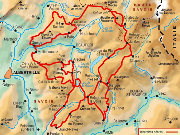


The Beaufortain Tour
The Beaufortain, a secretive massif, attracts walkers with its thousand chalets, its listed villages, lush forests and extensive high pastures. The Tarine and Abondance cows pasture there in summer. Accompanied by the sound of bells, hikers will reach farms to enjoy the taste of Beaufort, the famous local cheese. “The last happy valley in the Alps”, according to mountaineering writer Roger Frison-Roche, this massif is a jewel set between Tarentaise and Mont-Blanc.
The tour takes about six days to do it.
From Roselette chalet (1871m)
The trail meanders across the roselières des Prés (Reed meadows), by the chalets, and then down to the spring catchment, across the high pastures of La Balme. Carry on to the confluence of the creek that flows from the Jovet lakes, then walk up towards the Tumulus. Walk to the Col du Bonhomme, and carry on to the refuge de la Croix du Bonhomme (2,433m).
Level : average
Rise Time: 5h
Positive difference in altitude : 727M
Negative difference in altitude : 165m
From the cottage de la Balme (1706m)
Walk to the confluence of the stream descending from Jovet lakes and climb towards the mound. Cross over to the Col du Bonhomme, then continue to the refuge of the Cross of Bonhomme (2433m).
Level : average
Rise Time: 3h
Positive difference in altitude : 775m
Negative difference in altitude : 40m
From the refuge of Plan de la Lai (1820m)
Follow the Beaufortain tour trail north-eastwards to reach the col de la Sauce at 2,307m, then ascend the Crête des Gittes before getting to the refuge.
Level : easy
Rise time: 2 hours
Elevation: 800m
From Presset refuge (2514m)
First walk across the Grand Fond pass at 2,671m – descend the Combe de la Neuva (partly on névé depending on the time of year), extremely wild landscapes - La Raja Chalets (above Les Chapieux) – Ascent towards the Croix du Bonhomme refuge at 2,433m.
Level : average++
Rise Time: 5h
Positive difference in altitude : 830m
Negative difference in altitude : 911m
To the refuge de la Balme (the most common sense) (2009m)
Climb down Arrête des Gîttes (Gîttes crest) all the way to the Plan de la Lai refuge, then ascend the mountainside to the col du Bresson (a 450m elevation gain). Then it’s a short hike down to the refuge de la Balme.
Level : difficult
Rise Time: 7h15
Positive difference in altitude : 1050m
Negative difference in altitude : 950m
From Chapieux / Auberge de la Nova (1550m)
Follow the Tour du Mont Blanc footpath north-westwards to ascend to the refuge.
Level : average
Rise Time: 2:30
Elevation: 900m